

Read statements from the Conservancy advocating for improvements and protections to the Emerald Necklace and other Boston parks:
Advocacy
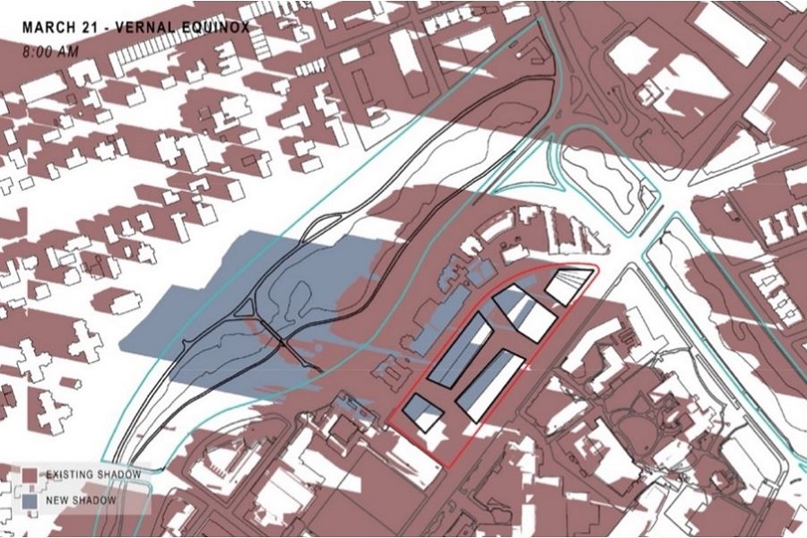
Charlesgate Revitalization
Our proposed design for Charlesgate Park will rebuild and expand a people-friendly and regional pathway network, restoring connections between the Emerald Necklace, Charles River Esplanade and Commonwealth Mall for the first time in more than five decades. When complete, this restored system will allow direct walking and cycling connections between locations as distant as Boston’s North Station, Charlestown, Dorchester, Cambridge and Watertown.
MassDOT included in its budgets and scope the reconnection of the Emerald Necklace and the Charles River Esplanade for bicyclists and pedestrians for the first time in over 60 years; interchanges that improve access and safety for pedestrians; and immense environmental and water quality benefits like the daylighting of the Muddy River at its terminal 250 feet.
For additional information on upcoming meetings and volunteer opportunities, graphics, maps, photos and further contact information, please visit the Charlesgate Revitalization page.
Muddy River Flood Control, Water Quality, Habitat Enhancement, and Historic Preservation
The Emerald Necklace Conservancy was founded in part as a result of the catastrophic flooding of the Muddy River in 1996 and 1998. The Muddy River project will have the largest single impact on the Emerald Necklace of any project in our lifetimes.
The goals of the project include improving flood control; water quality; enhancement of aquatic and riparian habitat; rehabilitation of landscape and historic resources; and implementation of best management practices. Construction of phase one of the project began in January 2013, and phase two began in autumn 2020.
For additional information on upcoming meetings and volunteer opportunities, graphics, maps, photos and further contact information please visit the Muddy River Maintenance and Management Oversight Committee (MMOC) website at www.muddyrivermmoc.org, the U.S. Army Corps website and the Conservancy’s page.
Opportunity to Restore Open Space in Franklin Park
The Shattuck Hospital was built on “Heathfield”, originally designed as a large meadow with shade trees, after 13 acres of parkland were transferred from the City of Boston to the Commonwealth for the purpose of building a hospital in 1949. The Shattuck Hospital building has now reached the end of its useful life and is slated for demolition by the Executive Office of Health and Human Services (EOHHS). Most services are planned to relocate to the Newton Pavilion at Boston Medical Center in the South End by 2025.
For additional information on upcoming meetings and volunteer opportunities, graphics, maps, photos and further contact information please visit our web page on the Opportunity to Restore Open Space in Franklin Park page or register to attend our next advocacy updates.
Access
Arborway Parkway Improvement Project
The Arborway is a nationally registered historic parkway originally designed by landscape architect Frederick Law Olmsted. The parkway is located in Jamaica Plain and runs from Circuit Drive at Forest Hills to Eliot Street by Jamaica Pond, where it merges into the Jamaica Way, part of Boston’s larger Emerald Necklace park system. Under the care and control of DCR, the Arborway includes several distinct sections, including Murray and Kelley Circles, the Arborway and Upper Arborway next to the Arnold Arboretum, and the eight-lane section between the two rotaries which retains Olmsted’s original parkway layout.
The goals of this project are to improve safety and accessibility for all users along the Arborway, create a better balance among the various demands placed on the roadway, and create a welcoming environment with enhanced public access that reflects the natural and cultural history of the site.
Over the course of this project, DCR will:
- Implement near-term safety improvements
- Develop design plans for sustainable and lasting improvements
- Select a final design and make improvements to the entire parkway
For additional information on upcoming meetings, graphics, maps, photos and further contact information please visit the mass.gov page on the “Arborway Parkways Improvement Project.”
Greenway Links Initiative
The Conservancy convenes its private and public partners to study and make recommendations to the transportation and parks departments of Boston, Brookline and the Commonwealth to improve non-motorized access to and between the Emerald Necklace parks and other greenway systems. Current initiatives seek to make walking, biking, and rolling easier at the Casey Arborway in Forest Hills, at crossings to Jamaica Pond, at Route 9 and the Riverway, at Charlesgate, and between the path in the Back Bay Fens and the Southwest Corridor Park path near the Museum of Fine Arts.
Public and Private Partners
Accessibility
Arborway Coalition
Boston Society of Landscape Architects
Emerald Necklace Greenway Project
Fenway Alliance
Fenway Civic Association
Isabella Stewart Gardner Museum
Jamaica Hills Association
Museum of Fine Arts, Boston
Northeastern University
Boston Parks & Recreation Department
Brookline Parks and Open Space
MA Department of Conservation and Recreation
Muddy River Flood Control
U.S. Army Corps of Engineers
Commonwealth of Massachusetts
City of Boston
Town of Brookline
Muddy River Maintenance and Management Oversight Committee (MMOC)
Emerald Necklace Conservancy
Public Funding of Parks
Boston Parks & Recreation Department
Legislation
Boston Parks & Recreation Department
